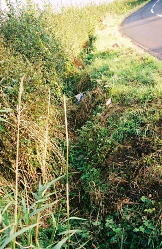
Car Accident
Alex Garfitt
Location: Near Oxford, between Shabbington
and Ickford, Oxfordshire, UK.
Date: 13/09/2001
Time of day: 17:16:05
Method: 1988 Honda Civic Shuttle 1.5l rotated through
90 degrees into a 1 meter deep ditch
"Conditions were perfect for a GPS Drawing like this - driving in the rain with worn tyres, fresh tarmac (more slippery), and of course a blind bend. The GPS receiver sat neatly in its dashboard mount as I approached a small crest in the road revealing a sharp bend a few yards ahead.
I slammed on the breaks initiating a graceful 20mph skid towards the ditch on the outside corner of the turn. The rear end of the car swung out to deposit the car passenger-side-down in the ditch. A protruding branch shattered the rear passenger-side window. The GPS remained neatly in its dashboard mount, it read 0.0mph. I was not injured and the car was a write off." A. Garfitt

The map from Garmin's Mapsource,
the journey (west to east) is lightly marked in green.
Final moments of GPS data:
Header- Position- Time- Altitude- Time - Speed - Course
Trackpoint N51.76236 W1.04926 13/09/2001 17:15:51 00:00:07 54.3 mph 129°
true
Trackpoint N51.76123 W1.04677 13/09/2001 17:15:59 00:00:08 59.6 mph 126°
true
Trackpoint N51.76065 W1.04550 13/09/2001 17:16:04 00:00:05 48.5 mph 126°
true
Trackpoint N51.76058 W1.04542 13/09/2001 17:16:05 00:00:01 20.8 mph 140°
true
Trackpoint N51.76058 W1.04542 13/09/2001 17:16:29 00:00:24 0.0 mph 0°
true